

Portable Navigator III (Raster & Vector)
Download User Manual
Download PNav 3.07 Demo Version
The latest release of Portable Navigator is 3.07.03.
Introduction
Portable Navigator III is the ideal data logging solution for towed
magnetic and sonar surveys
Portable Navigator III offers direct support of Aquascan Magnetometers
with its high speed multi-port, multi-channel NMEA DDE server with dynamic
averaging and data pre-processing it can combine data streams from multiple
instruments for serious data logging applications.
PNav 3.05 now includes simultaneous raster and vector chart support.
NMEAPro also provides Portable Navigator for Windows with full support
of the Yeoman Plotter for hand digitising your paper charts. You can also
use the Free worldwide coastline charts ! From the US Government Woods
Hole Field Center.
Additional features in 3.07.03 :
-Double size chart and route files - 10800 Chart points, 600 Waypoints and 40 Route Waypoints.
-Improved Route editing.
-New waypoint shapes.
-Longer custom NMEA sentence groups in auto-pilot output.
Examples of PNav in use.
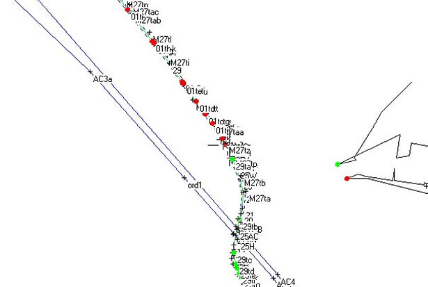
(Above) Part of the cable route relative to the harbour entrance of TAMSHUI harbour entrance. The red dots on the cable route indicate targets located with the AX2000 magnetometer, green dots show targets that have been diver investigated and cleared.

(Above ) Expanded view of a section of the cable route with the centre line and 20 meter demarcation lines outlining the survey corridor. Crosses denote targets detected during multiple survey passes along the route.
New Features
• Simultaneous raster and vector charts can be displayed
• New multi-media waypoint types include images and sound
• Multiple NMEA streams from up to 4 different com ports
• Support for the output formats of Aquascan® magnetometers
• Trend plot with "Data Zoom" to select and focus on interesting
data
• Auto generate survey grid lines for coverage navigation
• Optional document log for event fixes with auto insertion of screen
shots
• Additional parser terms for annotating Sidescan & Mag. chart
recorders
• Many other new and improved features
Standard Features
• Auto chart loading - Automatically loads the nearest chart to
the current position.
• Auto Zoom - Progressive zoom as you approach waypoints
• Instant configuration using multiple settings files
• Towed sensor configuration and coverage plotting for sidescan
sonar, magnetometers etc.
• Transfer route waypoints to compatible GPS receivers (e.g. GARMIN)
• New parser terms and waypoint shapes
• Enter waypoints in OS GB Grid format
• Position averaging including altitude
• Area calculation
The standard features include Auto Dead Reckoning mode if the GPS fails, log playback whilst still logging, tidal averaging for Course to Steer, and configurable Vessel Plan Orientation, Tow Geometry and GPS Antenna Offset. These last three features enable you to directly log the predicted position of towed sonar arrays, magnetometers etc., while carrying out hydrographic surveys in cross tide situations. Used with NMEAPro III, the new multichannel NMEA server from ESL, Portable Navigator III can log position and up to 10 auxiliary NMEA fields from up to 5 NMEA sentences on any combination of 4 different COM ports providing you with a programmable MUX facility
For latest price information please contact us.
